Every year, millions of people walk through the gates of the World War II Valor in the Pacific National Monument in Pearl Harbor, Hawaii to look back on the day that has lived in infamy. The USS Arizona Memorial, alone, draws in more than 1.8 million visitors each year to its majestic site.
Above the surface, the protruding remnants of Arizona's rusted hull provide visitors the chance to remember those who gave the ultimate sacrifice in protecting their brothers and country. A chance to honor those who are sometimes forgotten.
On this fateful day, however, divers under the surface were working to bring history back to life.
Just a few feet under the surface, Shaan Hurley, a technologist in the office of the Chief Technology Officer at Autodesk, a software company, carefully maneuvered through the silty waters surrounding the Arizona, navigating his way to key structures and components mapped out on a waterproof map of the ship.

Hurley's objective in photographing these important structures was so that eventual 3D models and printouts can be made to study, a technique referred to as photogrammetry.
Today, the corroded and twisted passage-ways and bulkheads of the Arizona are, to the surprise of some, teeming with marine life. Such an occurrence should, in reality, not even be happening given the Harbor's harsh environment, but nonetheless, nature has found a way, and in doing so, may have potentially put the ship's structural integrity in danger, according to Scott Pawlowski, Chief of Cultural and Natural Resources at WWII Valor in the Pacific National Monument.
“In the first surveys done in the early 80's, coral did not exist on the ship and one of the models that we have created to help us measure the longevity determined that coral was not a significant contributor to the model's accuracy,” said Pawlowski. “All growth happens in a logarithmic scale and what we're trying to do is find out where along the growth scale we are so we can double check our work from the past and be ready for questions about whether we should or should not manage it in the future.”
Since then, the National Park Service (NPS) has begun an extensive surveying project to develop high-resolution surveying data and models through the use of state of the art technology, like photogrammetry, underwater acoustic mapping and Light Detection and Ranging (LiDAR),
in an effort to better understand how the sunken remains of the Arizona and Utah, as well as various historic sites throughout Pearl Harbor, are changing with time.
“What's driving this project, at its core, is our desire to have high-fidelity measurements of the ship that we can then repeat over time and determine if things have shifted, changed or settled,” said Pawlowski. “But along with that, ours and the [National] Park Service's mission is also to help people develop a connection with the ship and explain why it's important, what's down there, and what the crew who were aboard the ship on Dec. 7th must have gone through. 3D models and data, presented well to the public, allow that connection to be made at a level that 2D or black and white can't.”
To accomplish this goal, the NPS has teamed up with a number professionals and subject matter experts located throughout the country in its latest week long effort; with each team bringing its own distinct expertise and skillset, at no cost to the Navy or NPS.
“This project is very special in that it's a partnership with a number of different companies and partners, as well as other government agencies, that have all come together and donated their time and energy, free of charge, to do this work,” said Pawlowski. “These are companies that believe in the importance of preserving cultural heritage and maintaining national monuments, like the USS Arizona.”
3D printed models of a coral-laden Coca-Cola bottle and cooking pot have already been created through the process of photogrammetry, but developing a 3-D model that captures the intricate details of the entire Arizona and Utah proves a lot more complicated.
According to Navy Diver 1st Class Ryan Crider, assigned to Mobile Diving Salvage Unit One, who was present during the surveying dives, poor visibility, razor sharp edges and structurally vulnerable overhangs maintain a clear and present danger to those who dive too close or unknowingly,
“One of the biggest concerns when guys are diving around the memorial is the visibility,” said Crider. “The visibility can get so bad out here that the chance of them getting lost is greatly increased. Another thing is the deterioration of the ship. Guys can get cut a lot easier or something can break off and fall on them. Also, with the oil leaking out the way it does, it takes a toll on the equipment and shortens its lifespan greatly.”
But, as we all know, the mission must go on.
So, as Hurley carefully found his way along the ship's exterior, technicians from R2Sonic, an underwater equipment manufacturing company, trolled a 17-foot dinghy above the surface and a safe distance away from the dive site.
Equipped with R2Sonic's sophisticated SONIC 2024 Broadband Multi-Beam Echosounder, the dinghy purposely made rounds up and down the sides of the ship, bouncing thousands of sound waves off the sunken hull and surrounding area in its wake.
A laptop aboard the boat was dialed in to the echosounder and received the acoustic data in real-time. With each pass, the crew began to witness the sunken ship slowly emerge onto the screen in, like a paintbrush on canvas.
The advanced technologies being used by R2Sonic today are a far cry from the real-time surveys of the past, which consisted of NPS rangers strapping on their dive gear, with only a pencil and pad.
“The advances in technology allow us to not do what they used to in the past, where divers used to have to go down with pads and in-depth measurements to map out a few points on a ship,” said Jens Streenstrup, president of R2Sonic. “Now, we, in a single day, can generate millions of points with super high precision within an inch.”
But aside from the poor visibility, the piercing metal and dangerous overhanging structures, surveying the Arizona still comes with additional challenges.
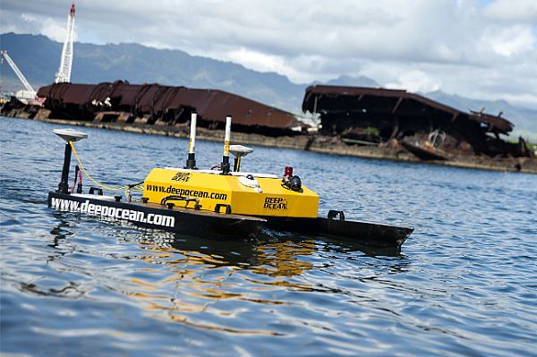
“Because the memorial goes over the ship, it has a low ceiling,” said A.J. Cecchettini, sales manager at Deep Ocean Engineering. “The depth of the water above the USS Arizona is very shallow, so you can't get in there with a boat and run multi-beam survey.”
And that's where the unmanned surface vessel (USV), USV H-1750, came into play.
At only approximately two-feet tall in the water, the H-1750 provided a method of collecting multi-beam survey data where its much larger, manned, brethren (the 17-foot dinghy) couldn't. Wirelessly controlled, the H-1750 fit into the nooks and crannies of the exposed wreckage, traversing underneath the USS Arizona Memorial with ease.
On land, John Tocci, director of virtual design and construction for Gilbane Building Company, set up LiDAR equipment to scan the terrestrial portion of the memorial. Once collected, the data will be pooled alongside R2Sonic's and shipped off to Autodesk to construct the final 3D renderings and models of the historic sites.
According to Tocci, the technologies being used at Pearl Harbor provides the opportunity to experience the wreckages and historic sites in dramatically new ways.
“Growing up and reading about (WWII) in 5th grade, the only thing you got was a black and white photo of Pearl Harbor and the current state of the memorial,” said Tocci. “But the fact that we can take this data and turn it into a three-dimensional walk-thru and show [the current generation] both the above and below water components of the Arizona and the Utah I think is going to be really exciting. It's going to take history and it's going to make it come to life for a new generation.”
However in the end, beyond the science, beyond the computer modeling and algorithms, remains the sentiment. The human connection.
“I think the thing that has surprised us the most about this project so far, is the visceral personal experience that working on such a place has on every member of the team,” said Pete Kelsey, Autodesk strategic projects executive. “Whether it's putting a [reconstructed] artifact in the hands of a 92-year old survivor who was here on Dec. 7th 1941, or showing it to kids in grade schools, [we're,] basically using this 3-dimensional data to ensure that what happened here, that story, this history…will not end.”
According to Pawloski, the ongoing project is estimated at a value of over $400,000, with the NPS having contributed approximately $10,000 of its own money towards acquiring the goods and services of those involved.
In addition to the computer 3D models being developed, a 3D model printout of the Arizona in its current condition is also expected to be produced and displayed at this year's Dec. 7th commemoration.
Via Navy.mil
Advertisement
Learn more about Electronic Products Magazine


