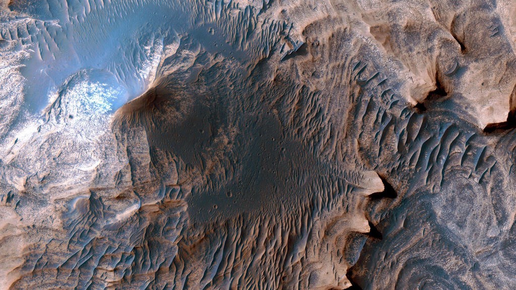
A new series of data captured by the Mars Reconnaissance Orbiter (MRO) enabled scientists to draft the most detailed, high-resolution geological map of the Red Planet to date. The map — just released Friday, Dec. 12, 2014 — was compiled by the U.S. Geological Survey (USGS) to highlight the Martian equivalent of Earth’s Grand Canyon, a region of the Valles Marineris system called western Candor Chasma. It can be downloaded here .
Since MRO began orbiting Mars in 2006, its High Resolution Imaging Science Experiment (HiRISE) camera has provided a level of detail on par with having actual geologists present to survey the landscape. This vast scale of topographical information allowed the USGS to apply the same mapping standards that are used when creating geological and structural charts on Earth, and by doing so, gain a better understanding of how the canyons are formed —a first time achievement for a planet other than our own.
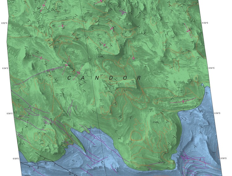
Cropped sample of the geological map, courtesy of USGS
The map elucidates the effects of large scale geological process and provides scientists with new goals in their continual search for habitable environments. Laszlo Kestay, USGS Astrogeology Science Center Director, said in announcing the new map, “One can see this map as a preview of the kind of geology humans will conduct when we eventually land on Mars. This also demonstrates how the very high resolution topographic and image data we can obtain from Mars' orbit enables scientific studies on par with rovers and other spacecraft that land on Mars.”
Prior to map’s creation, it was theorized that the Candor Chasma collected its sediment deposits from wind or volcanic eruptions located beneath glaciers in canyons; however, the USGS scientist who authored the map, Dr. Chris Okubo, observed that the western portion of the Candor Chasma contained evidence proclaiming the existence of numerous shallow, spring-fed lakes. “These lakes helped to trap wind-blown sand and dust, which accumulated over time and formed the extensive sedimentary deposits we see today.” In fact, the conditions at play within the Candor Chasma are parallel to what’s observed in Death Valley, California.
Another interesting observation: past seismic activity had also contributed to the wet sediment in the canyon by liquefying the sediments to form features called injectitite megapipes, which take the form of the low hills dotting the landscape.
Source: USGS.gov
Advertisement
Learn more about Electronic Products Magazine