While Light Detection and Ranging (LiDAR) laser systems have been around for a while, the technology’s use on small planes and drones in recent years has led to some amazing discoveries. This is perhaps best evidenced by the technology’s latest success, in which it located Las Médulas in León, Spain, a mining network considered to be the largest opencast gold mine of the Roman Empire.

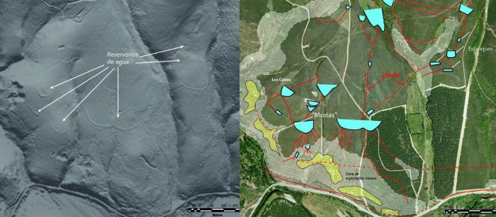
Ancient gold mines located in the Eria river valley. Model generated with LiDAR is on the left; aerial photos of valley on the right.
For those unfamiliar, Las Médulas was used by the Romans in the 1st century B.C. to extract gold. While difficult to locate, researchers knew of its existence due to its documentation in multiple texts, including those of Pliny the Elder, the Roman procurator in charge of overseeing mining in Hispania.
The problem in trying to locate the network is that its supposed location was blocked by either heavy vegetation or intensely ploughed areas. That, and the fact that the network was so large, made it difficult for archaeologists to establish its perimeters.
The LiDAR laser system allowed researchers to easily penetrate these too-difficult-to-access areas, and visualize the archaeological remains that lay below.
“The volume of earth exploited is much greater than previously thought and the works performed are impressive, having achieved actual river captures, which makes this valley extremely important in the context of Roman mining in the north-east of the Iberian Peninsula,” as Javier Fernández Lozano, geologist at the University of Salamanca and co-author of this study published in the Journal of Archaeological Science .
LiDAR uses a laser sensor to scan the ground using geographical references provided by GPS ground stations. Data recorded is represented by point clouds, which are processed using specialized software to construct a cartographic model where the forms are identified; this includes old reservoirs, channels, and building structures.
The technology was developed by NASA in the 1960s for analyzing the retreating sea ice in the Arctic and to study the composition of the oceans. Since then, its use has been extended to topography, cadastral mapping, geology, and archaeology.
Per the authors of the study, its use in locating the ancient Roman mining network marks the first time ‘geo-archaeology’ was performed with LiDAR in Spain.
“Our intention is to continue working with this technique to learn more about mineral mining in the Roman Empire and clear up any mysteries such as why Rome abandoned such a precious resource as gold from one day to the next,” concludes the researcher.
Via EurekaAlert.org
Advertisement
Learn more about Electronic Products Magazine


