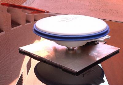
Researchers at Universidad Carlos III de Madrid (UC3M) have created a new system that improves a GPS’s ability to determine a vehicle’s position by 90%.

GPS prototype improves accuracy of current systems by up to 90%.
As if that’s not already impressive enough, the new technology can also be installed in any vehicle presently on the market, and at a very low cost.
Why did GPS need to be improved?
“We have managed to improve the determination of a vehicle’s position in critical cases by between 50 and 90 percent, depending on the degree of the signals’ degradation and the time that is affecting the degradation on the GPS receiver,” states David Martín, a researcher at Laboratorio de Sistemas Inteligentes (LSI) who worked with UC3M on this project.
Typically speaking, the average margin of error for modern-day GPS systems is 15 meters in an open field, where the receiver has wide visibility from the satellites. In an urban setting, though, the margin of error is much greater — tests showed that in some instances it was off by more than 50 meters. This is due largely to the fact that there are many more obstacles to deal with, including buildings, trees, and narrow streets. In cases where a tunnel is involved, the signal can be lost altogether.
The prototype the group created has proven to guarantee the position of the vehicle to within 1 or 2 meters in an urban setting.
How to improve GPS technology
So how did they improve current technologies by 90%? Quite simple actually — they added more sensors.
The two main components of the group’s prototype are a GPS and an Inertial Measurement Unit (IMU). The latter device integrates three accelerometers and three gyroscopes to measure changes in velocity and turns made by the vehicle. Everything is connected to a computer which takes this streaming data and inputs it into an application that merges the information and corrects any noticeable errors against the geographic coordinates being delivered by the GPS device.
“This software is based on an architecture that uses context information and a powerful algorithm (called Unscented Kalman Filter) that eliminates the instantaneous deviations caused by the degradation of the signals received by the GPS receiver or the total or partial loss of the satellites,” explains UC3M’s Enrique Martí.
Outlook
Currently, the researchers have a prototype that is working in a vehicle. They are using it as a platform to further research and experiment with the technology. Specifically, they want to capture and interpret as much information as they can get off the road. To do this, they’re using optical cameras, infrareds, and lasers to detect everything from if the car is crossing the lines of the road to where there are pedestrians in the vehicle’s path, and more.
“Future applications that will benefit from the technology that we are currently working on will include cooperative driving, automatic maneuvers for the safety of pedestrians, autonomous vehicles or cooperative collision warning systems,” the scientists said in a statement.
The end goal from a technical standpoint is to eliminate the computer portion of this technology and instead have all data run through the driver’s phone. “We are now starting to work on the integration of this data fusion system into a mobile telephone,” said Martí, “so that it can integrate all of the measurements that come from its sensors in order to obtain the same result that we have now, but at an even much lower cost, since it is something that almost everyone can carry around in his pocket.”
Story via: uc3m.es
Advertisement


